FAQ
How do I use TitanicMap?
The map is pretty much self-explanatory. Scroll and zoom around as you like. First, change to the full scree mode. To receive more information on a location simply click on the marker and an info box will pop open. You can switch off/on certain layers of information (see next section). If you’re looking for a specific location name or a location connected to a specific person, use the red search bar (magnifying glass icon).
What are the differences when using different devices?
Generally speaking, TitanicMap can be used with any device – however there are pros and cons for each of them:
– Desktop computer
A desktop computer with a jog dial (scroll wheel) on the mouse is best for exploring. Also for searching on TitanicMap with an unrestricted search function and easy switching on and off of different layers, a computer is best suited. When clicking on links (e.g. to read a biography or explore through StreetView), a computer is the most efficient way to switch between the tabs. A large screen is also most practical for the travel preparations, for example to estimate distances.
– Laptop
Like desktop computers, if used with a mouse without a Jog Dial (scroll wheel), however, much slower in navigation.
– Tablet
First choice when traveling. The tablet needs a data connection, when traveling abroad it has to be considered that a data package may be cheaper than paying for data volume via roaming. In order to display the present location of the device on the map, you must have logged in to Google and activated the GPS. This is the only way to approach a grave, as if by magic, even on the largest cemeteries. Or, if you select a marker and then tap on „Route“, then Google calculates the route and TitanicMap becomes the navigation device for all Titanic locations. The search function within TitanicMap may be restricted on some mobile devices. Important: not every country has the same power of the antennas; therefore the data reception can lead in particular in combination with the locating function to high battery consumption, we suggest that you have a power bank at hand. If you do not want to use roaming or data packets, you can also transfer the markers to an offline map (like MapsMe or CityMaps2Go) and take the photos as screenshots along – you will never get the real TitanicMap experience, but it will work.
– Smartphone
Like tablet, but with the smaller screen a little less nimble navigation.
I cannot open the full-size map – what do I do?
Several problems may cause this – here’s a fix you can try: You need to log into your google account (create one if you don’t have one already). If you’re not logged in, google maps may direct you to the general google maps page and not to TitanicMap.
Why are there different layers in the map?
The layers combine markers of the same location category and you can add or take away whole categories of locations on the map. In the default setting the following categories will be displayed:
„Titanic museums“, „Titanic places“ “Other Wrecks” and „Titanic route“. You can add the following categories: „Titanic businesses“ (contemporary businesses or companies that have a Titanic name, e.g. the Titanic Hotel in Berlin), “Cinema & Musical” (including set locations of various Titanic movies), „Titanic addresses“ (communities or street names that include the word „Titanic“), as well as „lost Titanic places“ (that includes location where e.g. exhibits, memorials and businesses used to be). If you’re preparing for an actual trip it is advised to start with all layers and get the maximum choice of locations worth visiting.
Can I switch the satellite image for an actual map?
You can switch between satellite image and map on the lower left side of the map (desktop) or in the settings once the map is on full screen (mobile devices). We find it easier to find actual locations using the satellite image, because some location features such as trees or large graves are not visible in the map, but very helpful for your on-location orientation.
How precise is TitanicMap?
As a rule, the buildings, monuments and tombs are marked exactly where they are. However, we do not have any influence on Google’s exchange of maps and satellite photos – this can result in shifts of up to several meters. In some cases, the exact location of a tomb has not been documented. Then the marker was placed at the entrance of the cemetery or on the cemetery building. In some cases, only the section of the tomb in which it can be found is known, then it requires some searching around the marker. Sometimes the section and grave number is known and mentioned in the description, but if there were no maps of the cemetery, the marker is still set to a neutral location. Overall, we estimate that currently (June 2019) over 95% of all markers on land are at the exact coordinates and can be found with the GPS function of a mobile device.
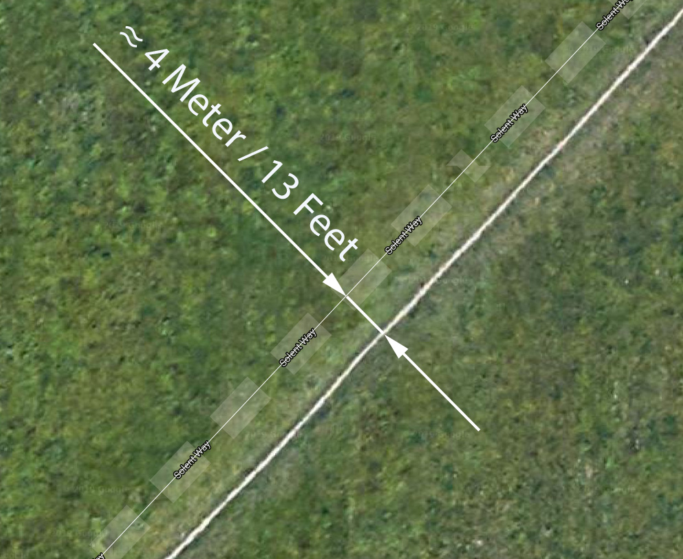
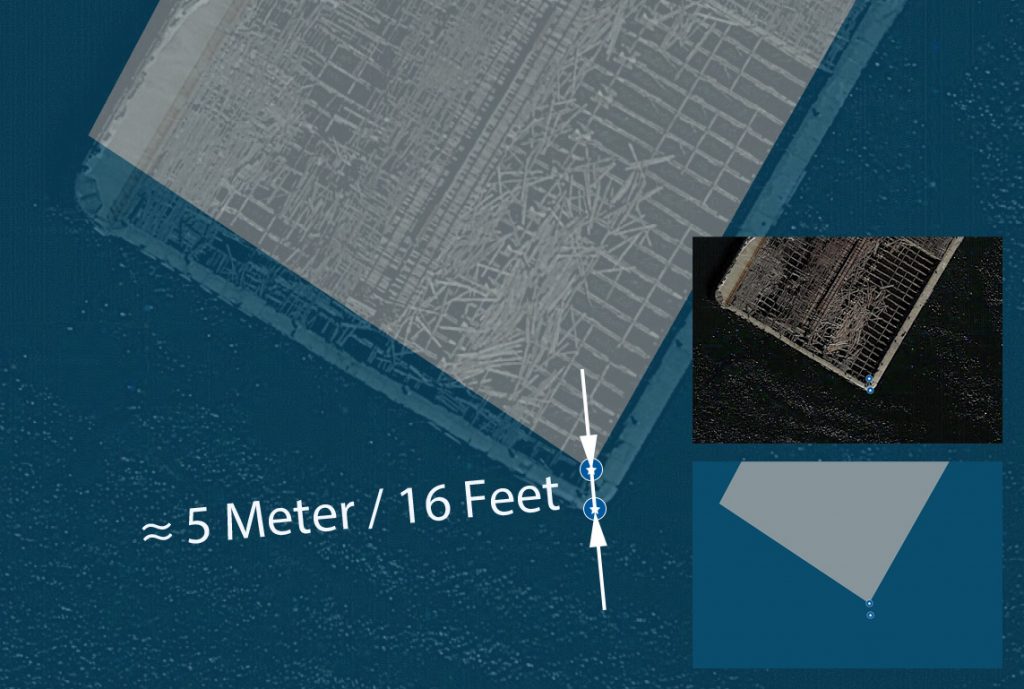
Examples of the deviation between satellite image and map. The markings on TitanicMap were set using the satellite image. If it is exchanged by Google, deviations can occur and cause confusion, especially on cemeteries because the graves seem to have „moved“.
What other information is on the map?
Each tag with a reference to a crew member or passenger has a direct link to the respective biography on encyclopedia-titanica.org. Once the location has been tracked by Google StreetView, another link will take you directly to the corresponding view.
Especially in the port cities with a Titanic connection individual buildings and facilities which no longer exist are drawn. This is for better orientation, for example when comparing historical photos.
Is the map up to date?
We try to do changes as soon as they become known to us. New monuments and exhibitions are added on an ongoing basis.
Can all places be visited?
There is no guarantee that the specified places can also be visited. The opening times of cemeteries, restaurants, institutions, exhibitions must be researched by the user of the map. If we are aware of restrictions (such as „private property“ or „by appointment only“) we note them on the respective marker.
Are all Titanic places marked on TitanicMap?
No. We cannot provide a complete map of Titanic places – no-one can. However, over time we try to document all known Titanic monuments, graves and other places of interest. Still, there are many other Titanic places such as buildings where Titanic survivors/victims lived or had businesses they owned. It is not our intent to systematically research and add locations like these. However, some places in that category have been added to TitanicMap. That may be the case if, for example, there is a plaque commemorating the Titanic survivor/victim on site.
Why are some Titanic passengers or crewmembers „misspelled“?
We are using the names and spelling of Titanic researcher Hermann Söldner, who’s aim is to research and document all Titanic passengers/crewmembers‘ names as given or used in 1912. Some survivors have (re-)married or Americanized their names in the process of naturalization in de USA and as a consequence have been buried under a different name. In these cases the name at the time of death is added to the information box connected to a marker. If you use the search engine both names/spellings can be used to find a marker.
Why are there some randomly added photos on some tags, but no photos on most tags?
Creating TitanicMap is a very time-consuming task. Photos will be added gradually. To simplify matters for users, in many cases the websites of institutions, cemeteries etc. are linked to our mark. As a result, Google accesses the image pool for the corresponding location. In total, ten images are generated. As soon as we assign our own images to a mark, these are shown first, followed by other Google photos. For markers that are not linked, images will only be displayed once we have uploaded them. At a later date, we will ask users of the site to share photos of some places with us.
Some graves are named „cenotaph“. What does that mean?
Basically a cenotaph „pretends“ to be a grave. No actual remains are buried at its location, but unlike a general monument they are located at a cemetery and look like a grave. The purpose is to give the mourning family or loved ones a substitute to a grave. Many Titanic victims could not be buried because their bodies were not found after Titanic’s sinking. There are also cases where a Titanic victim’s name was added to a family gravestone. So even though it is an actual grave, the person listed on the stone is not buried there, and we have listed the stone as a cenotaph, because it is in regard of the Titanic person commemorated on the stone. Cenotaphs can mostly be found on cemeteries on TitanicMap, commemorative plaques that are not located on cemeteries are simply referred to as memorials.
What are the criteria for adding a location to TitanicMap?
In general we like to add locations that are, in the most basic meaning, Titanic sights – places where you can look at something Titanic-related. Graves and monuments are instantly added to the map once we find out about them, even when the headstone is missing (which will be mentioned in the description). We’ve ignored most birth places, living quarters and workplaces, since this would add thousands of markers, and it would make the map rather random, as it is impossible to systematically find all places eligible. These kinds of locations are only marked if there is a commemorative plaque on site.
I know a Titanic location that is missing on TitanicMap. How can I add this location?
We’re happy to learn about further old and new Titanic places. However, you cannot add them to the main map yourself, only the administrator of the map can. Instead, we’ve provided an „empty“ map in the section „add a Titanic place“ (top menu). Simply find the location you want to ad and set a marker. Please also include all the relevant information about the location. However we reserve the right not to add places to the map.